
By: Korie Marshall
The Ministry of Jobs, Tourism and Skills Training held open houses throughout the McBride to Barriere corridor last week, trying to gauge interest and share information about a potential Geopark designation for the area.
Global Geoparks are “areas of geological heritage of international significance where this heritage value provides a framework for regional sustainable economic development and a rationale for safeguarding the environment.”
The Geopark designation is a potential marketing tool that could bring international awareness to both the interesting geological features of our area and the ways the geology has affected our cultural and historical development, proponents say. This would have value for modern travelers who are looking for a story about the places they travel to, according to a new “Explorer Quotient” or EQ philosophy of tourism marketing.
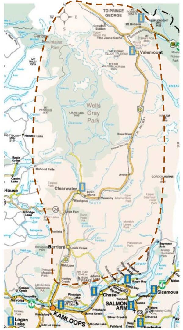
Right now an approximate geographical area is under discussion, but Jennifer Houiellebecq of the Tourism Planning Group, consultants for the project, says it is important to note that what is being considered are specific “Geosites” – smaller areas that are of international significance – not the entire area.
The presentations in Valemount and McBride outlined the current proposal – a preliminary series of Geosites, all of which are existing BC Parks and provincial recreation sites, including Mount Robson (a UNESCO World Heritage Site). Potential geosites include Wells Gray Provincial Park, Mt. Robson Provincial Park, as well as several provincial parks close to Clearwater and Blue River.
The Geopark must foster sustainable economic development, largely through the development of geotourism, and educational programs must be developed and operated.
Myles Bruns, regional manager for economic development with the ministry, says those educational programs could be cultural tours with Simpcw First Nations; tours and interpretive information about the impacts and operation of hydro dams like Kinbasket Reservoir; or tours of historic communities like what remains of the old Tete Jaune Cache town site.
Houiellebecq says the approximate costs of becoming a Geopark can vary, but threw out numbers like $80,000 for the mid-range cost to build a good application. That could result in 25 new jobs after five years, says Steve Nichol, also with the Tourism Planning Group. Those numbers are preliminary, and are difficult to quantify, since accurate numbers of visitors through the area are not available right now, but the costs and benefits would be shared throughout the region with whatever communities that want to be involved. One small business owner who traveled from Blue River to join the open house in Valemount was concerned this could be just one more place to split a small buisness’s advertising dollars, but Houiellebecq says that doesn’t have to be so. If communities wanted, they could spend their money on this, instead of other programs. Or, marketing funding from programs like Valemount Tourism for example could even be rolled into the Geopark program.
Houiellebecq says she and Nichol have realized through doing the open houses that the plan will likely need a local champion for the project in each area that wants to participate. The next steps will be ensuring there is community support in principle; developing the application, management plan and business plan; reviewing the potential for the Geopark to strengthen the visitor’s experience; and offering some community-wide opportunities to develop awareness of the corridor as a potential Geopark.
Houiellebecq says the proposal will be presented to the steering committee soon for a decision on how to proceed. The project steering committee is made up of representatives from Simpcw First Nation, Barriere, Clearwater, Sun Peaks, Valemount, McBride, Thompson-Nicola and Fraser-Fort George regional districts, Tourism Wells Gray, Thompson Okanagan Tourism Association and Thompson Rivers University.
With files from Frank Green
