
Unlike photographs of people from 100 years ago, images of mountain landscapes have not seen the same dramatic changes in style.
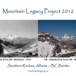
But subtle and not-so-subtle changes to mountain landscapes in places like Mt. Robson Provincial Park are the subject of ongoing research to record geological change, known as the Mountain Legacy Project.
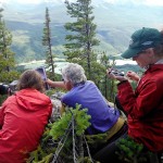
A group of researchers primarily from the University of Victoria is currently comparing old topographical and geological photographs to current landscapes by taking new photos of the same scene using GPS information to align their sights.
Research supervisor Eric Higgs, director of the U of Vic School of Environmental Studies, says the mountain region connecting BC, Alberta, and the Yukon is blessed to have a legacy of photographs from as early as 1888 taken for the purposes of mapping.
“The photos were excellent quality and they took a look at the landscape at a time that was pivotal in the park’s history,” he says.
Higgs says images are very useful to land managers. They provide an indicator of climate change impacts and human impacts over long periods. He says the idea is to create an ongoing database for researchers and nature enthusiasts.
“It’s very helpful for setting a baseline and for projecting into the future,” he says.
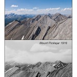
Their research has been ongoing since the late 1990s, and began in Jasper National Park in 1998. They discovered 700 images from 92 mountain stations in that area.
“What we didn’t know when we started was that this was just the tip of the ice berg,” he said.
Between the National Archives, the BC archives, there are 140,000 images between 1888 and 1958 that cover the mountain maps of BC, Alberta and the Yukon. He says it is the most extensive collection of historic mountain photos in the world.
“Just about every rock in those three areas has a photo from it, taken by either geological survey or topographical survey,” Higgs says.
Luckily, the surveyors used state-of-the-art photography equipment at the time. Higgs says his computer science colleagues are looking at models for analyzing the change in these photographs.
How do they reproduce photographs from the same elevation and angle? They try to locate stations on Google Earth, using approximate GPS coordinates. They then locate the area in person or via helicopter. After choosing a landing spot, they hike to the station and fine-tune the exact location as closely as possible with the photos.
Jenna Falk is a Master’s student in Environmental Studies at the University of Victoria and the crew leader for the Mr. Robson and Willmore Park portions of this year’s study.
She says the last century has seen considerable cultural, climatic and ecological change to mountain ecosystems in Western Canada.
“Our views surrounding nature and wilderness have shifted with remarkable swiftness during this time.”
She says these changed views have led to increased human intervention and management of remote natural systems.
She says park and protected area management is fraught with political and social complexities. Remote ecosystems are often assumed to lack direct human impacts and therefore lack any need for restoration or management, she says, though often that is not the case.
Falk says she is looking at how long-term landscape changes by fire suppression and climate change, for instance, affects conservation objectives; what challenges these landscape changes present for parks management; and what the challenges exist in managing remote ecosystems.
In addition to photos, she plans to conduct group interviews with park rangers and area supervisors.
Historic survey photographs used in Mt. Robson Provincial Park are from the 1913-1923 Interprovincial Boundary Survey of the south and western boundaries by Wheeler and Cautley. This collection will also be used in Willmore, in addition to the 1944-1945 surveys of the southeastern boundary of the park by Nidd.
Visit their website: www.mountainlegacy.ca
